M&Soft launches 7-inch Mappy AP1 PND in South Korea

| 0 comentários

M&Soft launches 7-inch Mappy AP1 PND in South Korea


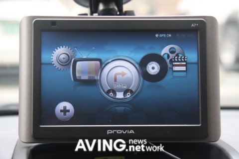
M&Soft's Mappy navigation software seems well established in Korea, and now the company has decided to offer its own hardware for it in the shape of a 7-inch SiRF-based touchscreen device. Of course, it wouldn't be a South Korean PND if it didn't include a DMB digital TV tuner, video and audio playback, and a photo / text viewer, but the company's gone one better by offering the elaborate, gimmicky GUI you see above. Pricing is pretty decent too, set at 349,000 KRW ($283) with a 4GB SDHC card, or 399,000 KRW ($323) for an 8GB unit. The AP in the model name stands for 'Absolute Pride' -- sure, make your jokes, but maybe it's that wise-guy sense of humor keeping this sort of tech away from Western shores.


[Via Slashgear]

Clarion MiND - now a lot cheaper

| 0 comentários

Clarion MiND – now a lot cheaper

clarion-mind

Clarion MiND - since we last visited - has it’s own page now showing off its features. And even though it says you can grab one as low as $500, Amazon is not taking any chances and is willing to get rid of them for $250.


clarion-mind-screen


What do you think of this price? Are you willing to spend $250 for a WiFi enabled device with a 4.8″ screen and 4GB of flash memory? It is also bluetooth enabled which is good - but it is only way to get wireless internet when you are not close to any WiFi hotspots. You’d have to pair it up with your phone to get connectivity. Anyhow - what can Clarion MiND do for you? GPS navigation, play your tunes, new traffic updates service, and Google Local search.


(Via NaviGadget.)

Mio Moov M300 and M400

| 1 comentários

Mio Moov M300 and M400

Moov_M400_1

After its recent sat nav systems such as Spirit Moov series Mio just announced two new GPS navigation systems: Moov M300 and M400.


M300 is the smaller of the two and offers a 3.5″ screen with 320x240 pixels resolution. The numbers are 4.3 inches and a resolution of 480 x 272 pixels for the M400.


The M300 incorporates a map of France and is currently marketed at a price of 99 €. The M400 incorporates maps from 23 countries of Western Europe and is available at a price of 149 €.


Both come preloaded with speed radar locations and 1 year worth of free upgrades. Beyond that, it is € 30 per year for France.


The M300 and M400 also come with ‘local’ Mio which lets you search for addresses, including restaurants and shops, from your PC with the Yellow Pages and load them directly into your GPS.


The M400 also offers the NavPix photo navigation: with its integrated photo album, you can view photos of tourist sites, beaches, hotels and restaurants and then be guided directly to the chosen location. You can also retrieve for free from sites NavPix and Flickr, offering more than one million geotagged photographs.


Also worth mentioning is that the M300 and M400 do not have the latest software - Moov Spirit - that is available on the Spirit Moov 300, 500, HF 500 and Moov Spirit V505 and V735 TV TV.

Moov_M300_1


(Via GPSandCO.)

Garmin Nuvi 1350T Lightning Review

| 0 comentários

Garmin Nuvi 1350T Lightning Review

The Gadget: Garmin Nuvi 1350T, a reasonably affordable, full-featured, ad-supported portable navigator from Garmin—possibly the last PND we'll ever review.


The Cost: $350 list; $310 online


The Verdict: Portable navigators are great, but they've reached equilibrium: Prices have never been better for the functionality you get, but if the 1350T proves anything, it's that there's nowhere they can go from here.


I hope you recognize that's not a complaint: Forget all those frilly features like voice command and Bluetooth, stuff that you love for a short while but (I fully admit) never use later on in the product's life. It's the basics that count, and the 1350T has basics, plus a slightly tweaked interface that improves on the old Nuvi experience without changing it too noticeably. It's faster than even the higher end Nuvis I've looked at, and has a streamlined main navigation screen that proves that, unlike TomTom, even when you have a winning formula, you have to keep tweaking it. Overall use is still the best in the business.


The 'T': It's for 'traffic' and it can be helpful if you use it correctly, though that's one of my only gripes: Delays show up in minutes, but there are times when you're sitting still for 5 to 10 minutes and you just see '0:02,' and other times you are stuck only momentarily and it shows '0:07' or more. The problem is, it's a moving average. It's not saying you'll be stuck there for that long, necessarily, but that the overall trip arrival time has been changed. It's a bit heady, I think. That or it's simply inaccurate.


The real trouble with traffic is that the best way to deliver streams of information is via a cellular data connection—on demand. (The 1350T has a receiver, but it's not a communicator.) As it happens, nobody is willing to pay for a separate cellular connection to get traffic (and local search) data, because they already have phones that cost a load in monthly fees. Phones aren't yet ready to inherit the GPS world from the portable navigators, but the newest raft of iPhone apps, the latest SiRF GPS chip announcement, and Garmin's own dabblings in the cellular market, prove that it's just a matter of time.


The Ads: The weirdest part is that the 1350T is ad-supported. It's not annoying yet—there are only two ads that I've seen, for Best Western and Walgreens, and they tend to hover in the peripheries. But they could get a lot more frequent and more visible. At the moment, these national chains aren't really targeted to your route, but eventually, this system could suggest stuff at every turn along your route. Is that cool? Maybe, if it comes with like Big Mac coupons and stuff. But most likely not.


The End?: As I mentioned, what the 1350T represents is the logical end of the PND, a highly functional and almost comfortably limited device. We now face an unknown transition, during which time an awful lot of people will buy an awful lot of old-school priced-to-move navigators.

(Via Gizmodo: GPS.)

Amod GPS Photo Tracker review

| 0 comentários

Amod GPS Photo Tracker review

amod-gps-tag-02

This is how I like to review things: Take it out of the box. Charge it/put batteries in it - then use it. No manuals, no quick start guides, no settings, no configurations. This is exactly what I did with the Amod GPS Photo Tracker.


Right before I went on a camping trip I took my camera with me, opened the box for this little GPS photo tracking device, put in the 3 AAA batteries it needed, and then hit the road. I figured it can’t be to complicated to use a device with two buttons and 3 LEDs. One of the buttons has the power icon on it, the other - a flag. The LEDs are for memory, satellite signal, and battery power. After we left the city I turned it on. The green satellite LED was solid at first - few moments later it started blinking and stayed that way. First I thought blinking can’t be good. But than I thought in normal working state a blinking LED would save a lot of energy compared to an always on LED. It turns out blinking green satellite LED means all is good and we have satellite fix.


Then during the rest of the trip every time I took a picture I hit the little flag icon on Amod GPS photo tracker. Sometimes the device wasn’t within my reach so I didn’t bother. Sometimes I forgot to turn it off after I used it. I made sure I used the device carelessly and wanted to see if it was ‘fool proof’.


After the trip I sat in front of my PC, emptied out my digital camera’s SD card on to my computer as I normally would. And then I found the CD that came in the box double clicked the ‘setup’ to install the software. That went pretty smoothly. After that using the USB port of the Amod GPS Photo Tracker I connected it to my PC. My Windows box immediately recognized the device. Still no glitches… Going well.


When the software was ready I first found my pictures and then I found my GPS logs. I had about 10 - 12 that needed to be tagged. And then a few more between those that I never tagged. With the hit of a button the software immediately found all the pics I had tagged, and told me which ones were not tagged. Then after that I was able to fly in to the area where my pictures were taken using Google Earth. All that worked pretty good.


As a final note I can easily say the device is quite easy to use and it does what it promises. Thumbs up.


(Via NaviGadget.)

landrover’s iPhone GPS navigation app

| 1 comentários

landrover’s iPhone GPS navigation app

landrover-iphone-app

Now Land Rover has joined our list of iPhone GPS navigation systems. Their developers are not quite experienced as others in the fields, so you won’t be getting your dynamic turn by turn directions with this app. Nor will you know what street to take or anything like that. It just draws a straight line from your start point to your destination and calculates the distance for you. You know why? Because if you have a Land Rover Defender that how you’d drive. In a straight line.


We haven’t tested it but it seems like the app also lets you pick your own Land Rover - customize it, etc…


(Via adsoftheworld.comt.)

TeleNav for iPhone review

| 0 comentários

TeleNav for iPhone review

iphone-telenav-01


Just recently I had a chance to review the new AT&T Navigator (powered by TeleNav) for the iPhone.


I’m usually a bread and butter kind of guy. I like simple things. The basic map application on the iPhone use to be sufficient for my needs, but being that its hard for me to drive and type addresses into my phone; I needed another solution. Not to mention that its illegal to play on your phone while driving. Not that I would do anything like that… So, I bought a cigarette lighter mount for my iPhone so that I can use Telenav, charge my phone and listen to my music via the car speakers.


iphone-telenav-02

Telenav’s user interface is very straight forward and easy to use. The Drive To selection allows you to choose from your favorites or places you recently looked up. The Business feature is really cool, and I used it quite often to find the cheapest gas in the neighborhood. You can type in names of businesses or select from business types, and Telenav will give you concise directions to the destination you select. The intersection ‘Call it’ feature works very well when you have the phone to your ear or when you have a headset. However, trying to use the call it feature with the speaker phone can be frustrating when there is a lot of background noise. The system seems to misinterpret what you are saying. When the call it feature is selected the app switches to the phone and makes the call.


iphone-telenav-03


Once you have verified you destination and end the call, the app seamlessly starts up again. The app then gives you the options of starting navigation or saving the location to your favorites. One of the downsides of Telenav is that you cannot view the map in a landscape horizontal view like most stand-alone navigation systems. This is some what of a downside in my situation since the cigarette lighter mount that I have for my Honda Civic is mounted below the dash and its hard to see the street names. Not to mention that the most stand-alone navigation systems have bigger screens. If it could go horizontal it would alleviate this problem. I give this application an 8/10.

Pros


  • Voice directions were good and very responsive.

  • Graphics were very good for the iPhone.

  • Gas prices were always accurate and up to date.

  • Call it feature works very well and is very user friendly.


Cons


  • Landscape map not available

  • Automatically assumes that you can get into the HOV lane, should have a feature that lets you specify the number of people in your car.


(Via NaviGadget.)

iPhone GPS app for North America from Navigon is out

| 0 comentários

iPhone GPS app for North America from Navigon is out

navigon-iphone

It is one of those cases where the title says it all. The MobileNavigator for iPhone from Navigon which we talked about here and here has recently made debut at the Apple App Store.


The introductory price for the application is $70 which is good until August 15th. After that day the price is supposed to go up to $100.


Here is what you need to know about MobileNavigator for iPhone.


  • no monthly fee - cheaper in the long run

  • on-board maps - maps don’t download as you go. You’ll have access to all the maps when you don’t have coverage. However we can’t say the same about the GPS signal.

  • takes 1.29GB of space on your iPhone

  • supports landscape view


So are you getting one? - or are you holding out for other iPhone GPS apps?


(Via NaviGadget.)

tomtom iPhone GPS navigation app coming out soon

| 0 comentários

tomtom iPhone GPS navigation app coming out soon

iphone-gps-navigation-tomtom-04

TomTom CEO Harold Goddijn - during a quarterly earning call - said that their iPhone GPS navigation application is on track and it will be launched in the US and Europe at the same time via the App Store. The car kit for the application - which is optional - will be available through the TomTom website and other retailers he mentioned.


As you know there are many options for GPS navigation on iPhone - and already a few of those options beat TomTom to market. Just recently for example Navigon made the US version of their GPS navigation available via the App Store for an introductory price of $70 and no monthly fees… >

(Via NaviGadget.)

Smartlinq GPS Phone brings the inbuilt emergency tracking system to fore

| 0 comentários

Smartlinq GPS Phone brings the inbuilt emergency tracking system to fore

smartlinq gps phone


It is not that we haven’t had GPS integrated phones before the Smartlinq GPS option, but the way this phone brings the-emergency tracking system-to fore is what makes it special. There are a minimum set of buttons you can expect from a phone and this cluster has been coupled with an on-board GPS which will never let you disappear. The elderly are the ones who would supposedly benefit the most from this offering. Indeed, they would love it for the presence of a full operator service. If nothing seems to work for you in an emergency, there is an SOS button that will summon help in a jiffy. Smartlinq bears a price-tag of £149.99 with a £12.99 monthly fee for a Careline Package.


(Via Cell Phone Beat.)

Cheetah GPSmirror

| 0 comentários

Cheetah GPSmirror

Cheetah GPSmirror


Drive a fast car, but don't want to pay the price of making light of the speed limit? Here's the Cheetah GPSmirror that might cost a pinch at first with its $250 price point, where it comes with an integrated GPS system that will alert you of upcoming enforcement cameras along the way after consulting with its huge database that comprise of the US, Canada, Europe and Australia. In addition, it will also come with voice, tone, and visual alerts, advisory speed limit announcements, a GPS-based speedometer display with compass and the ability to provide you with current GPS coordinates just in case you're stuck in a rut.


(Via UberGizmo, the Gadgets News Blog.)

Sony Latest GPS Navigation Device With 6.1-inch LCD

| 0 comentários

Sony Latest GPS Navigation Device With 6.1-inch LCD

Sony Latest GPS Navigation Device With 6.1-inch LCD


Sony has released their latest PND in the form of the NV-U3DV. The gadget provides a 4GB of internal storage and a 6.1-inch WQVGA (480×272) LCD screen, which is larger than most GPS navigation gadgets on the market. The Japanese version of NV-U3DV will have an antenna for television broadcasts. Users can also play their own movies, music, and pictures (MPEG-4/AVC+H.264 with restrictions, MP3/AAC up to 320kbps, and JPEG). No word on pricing so far.

(Via TechFresh.net - Cell Phones, Laptops, Video Games, iPods, Cameras.)

SPOT GPS Tracking Device Now a Smaller, More Powerful Lifesaver

| 0 comentários

SPOT GPS Tracking Device Now a Smaller, More Powerful Lifesaver

The Survivorman approved SPOT GPS tracking device is now 30% smaller and lighter than the much beloved original version. More importantly, the chipset and the antenna have been upgraded to improve performance.


Other improvements include an LED light that indicates the status of your sent message, a separate tracking button, an extra message button, universal communications symbols and a stylish new silver finish option. Pricing for the new unit will most likely be revealed in the fall when the new SPOT is scheduled to hit shelves. It probably won't be cheap, and the tracking service already costs at least $100 per year, but that is a small price to pay for peace of mind when you are stuck on some godforsaken corner of the Earth.

(Via Gizmodo: GPS.)

UK: Cheapest Bluetooth GPS module is a steal!

| 0 comentários

UK: Cheapest Bluetooth GPS module is a steal!

royaltek 1 UK: Cheapest Bluetooth GPS module is a steal!


Staying in the UK retail space for a moment, MobileFun.co.uk have let me know about a Bluetooth GPS module that is retailing for a cracking £19.95 - a full 59% cheaper than its usual retail price!


The main features are:


  • Highly portable, the receiver can carried in your pocket, around your neck or in the car

  • The receiver has non-slip feet for mobile positioning within a car

  • The Bluetooth GPS Receiver will work with your Bluetooth enabled mobile phone, laptop or Netbook

  • Allows you to join the GPS revolution with little outlay

  • Although the receiver has 7.5 hours battery life, it can actually be manually switched on and off to lengthen the battery life considerably

  • The receiver will enable you to download and use multiple GPS applications that are compatible for your phone

  • Our Bluetooth GPS Receiver is made by RoyalTek an awarding winning manufacturer from Taiwan

  • 30 day money back guarantee

  • 1 year warranty


And in the box you’ll get:


  • RoyalTek RBT100 Bluetooth GPS Receiver

  • Li-Ion Battery rated at 3.7V 680mAh

  • Windscreen / Dashboard Car Mount

  • Car Charger

  • Mains charger

  • Quick Start Instructions


And again, all this for £19.95 - bargain!


[Via: MobileFun.co.uk]


Samsung Mondi does GPS and a whole lot more

| 0 comentários

Samsung Mondi does GPS and a whole lot more

samsung-mondi


Samsung just officially announced Samsung Mondi, a mobile WiMAX-enabled handheld device for the U.S.


Samsung Mondi has a 4.3″ touchscreen, support for 4G networks, 3MP camera, WiFi, and offers a full qwerty keyboard. But most importantly (to us) has integrated GPS receiver - which powers the Route 66 GPS navigation software.


At the same time Samsung Mondi was announced CLEAR - the high speed mobile internet provider announced their 4G availability around the Las Vegas area - which the Mondi can take full advantage of. The touch screen Mondi, which is Latin for ‘world,’ is designed for use with the Clear Mobile WiMAX service from Clearwire in the activated markets of Atlanta, Las Vegas, Portland, OR and future WiMAX markets.


Here are some more features:


  • Windows Mobile 6.1

  • Microsoft Outlook and Windows Mobile Office

  • WiMAX Mobile Internet Access

  • WiFi Access (BTv2.1+EDR)

  • GPS: Route 66 Navigation with Preloaded Maps

  • 4GB of Internal Memory

  • Direct Push/Mobile Email (POP3, IMAP, SMTP)

  • Supports Instant Messaging and MMS

  • 3.0 Megapixel Camera and Camcorder

  • Bluetooth ® 2.0

  • Opera 9.5 Web Browser

  • HDMI TV Out

  • Supports Multiple Video and Audio Player Formats


Samsung Mondi will be available at Clearwire retail outlets and select Best Buy stores located in Atlanta, Las Vegas and Portland, OR starting August 1, 2009.


(Via NaviGadget.)

Navigon on Android

| 0 comentários

Navigon on Android

navigon-android-2

Navigon will be announcing their GPS navigation system software for the Android platform in August - Navigon MobileNavigator 7.


A 30 day trial version will be available for free which will even include speed limit warnings, and POIs along the way. There will also be a pedestrian version of the GPS navigation system included in this trial version.


You may find a restaurant through the recommendations of the social network Skobbler, and can also save rating and even send them directly to the communication tool Twitter.


Navigon MobileNavigator 7 for Android will be completely over the air. The maps are stored on a server and routes are also calculated by the server and then downloaded to your device. Of course you’re strongly advised to have a high speed data service on your phone before anything else.


This will be the first time for Navigon to offer such GPS navigation platform over the air. Navigon will be competing with the U.S. publisher ALK which already sells its navigation software CoPilot Live 8 for Android smartphones. Navigon MobileNavigator for Android goes on sale in August for 69 € with regional maps and for 99 € for the complete European version…

navigon-android-1


(Via NaviGadget.)

TerreStar completes testing of satellite phone system

| 0 comentários

TerreStar completes testing of satellite phone system

elektrobit satellite phone TerreStar completes testing of satellite phone system There used to be a time when satellite phones came attached to briefcases (much like the first cellphones, in fact). More recently, sat-phones have grown small enough to carry in a pocket, but still came with chunky waistlines and awkward antennas. TerreStar is looking to change all that with their TerreStar satellite phone service and TerreStar hybrid cellphone. Following the launch of their TS-1 satellite earlier this month, TerreStar has just completed testing a pair of slim(ish) ‘TerreStar Satellite/Terrestrial’ smartphones in an end-to-end test call routed through the company’s TS-1 communications satellite orbiting Earth.


The successful completion of the TS-1 satellite and the TerreStar Satellite/Terrestrial brings us one step closer to realizing the dream of carrying a fully-functional satellite phone in the tightest of pants pockets. And, with the ability to work over traditional cellular networks (TerreStar is partnered with AT&T (NYSE: T)), the TerreStar sat-phone system promises to make the best use of pricey satellite minutes.


We’d like to get our hands on the 0.8-inch thick Windows Mobile 6.0 Professional smartphone - made by Elektrobit - and its 2.6-inch touchscreen, 3-megapixel camera, WiFi, 3G (HSPA) and GPS receiver. Alas, we’ll have to wait for more information from TerreStar. The company plans to bring their service online by the end of the year. We’ll probably know more soon.


[Via: WindowsForDevices]


(Via IntoMobile.)

Things to consider when buying a GPS System Equipment


There are three different satellite navigation systems used around the world.
The most common is the US Global Positioning System (GPS) or NAVSTAR witch uses uses 24 satellites. In fist place originated by the US military, GPS is now widely used for civilian purposes, for example GPS are used by cars
Galileo was launched in Europe in 2005 and was considered a rival system to NAVSTAR system. And there is also a Russian system called GLONASS.


When searching for sat nav deals you need to take in account the following things:

- Decide the purpose of use of the GPS and how often you intend to use the equipment (driving around city streets, hiking mountains or touring the Virgin Islands in your yacht? Each intended use has its unique needs, whether it's street maps and directions, topographical and altitude information or extra battery power);
- You need to decide how much you want and have to spend (budget)
- Decide what kind of maps you'll need (general, what-state-am- I-in maps, or precise city-driving directions?); And of course 2D and 3D maps. Newer models comes with 3D maps already.
- Choose a system that offers updates of the point-of-interest data (Most GPS systems include locations of airports and other transportation services, ATMs and banks, restaurants, hotels and a host of other sites); Pay attention also on the fact that a lot of units come with this POIS and maps already installed on the GPS and some units requires a download and install procedure.
- You need to decide with brand you are going to buy: Garmin, Mio, Magellan, Alpine, tom tom sat nav, Pionner, Cobra, etc....
- Turn by turn directions, and vocal as well as graphical directions (Some systems uses a map and monitor that include arrows that show you the direction of a turn and also indicate where your car is on the map in relation to the destination);
- Look for features such as audible alerts that warn you of upcoming intersections or turns, and scrolling maps to track your progress;
- Select a system that features multiple ways of getting to your destination (by address, by intersection, by a personal address book or via a location selected directly from the map);
- The screen type and size (most of the units now are 4.3 inch and touchscreen but there is a lot of GPS units that still comes with 3.5 inch touchscreen).

http://www.satnav-expert.co.uk/ is a great website that will help you to choose and compare cheap Sat Nav Deals.


By GPS World

Solara Field Tracker 2100 GPS With Satellite Text Messaging

| 0 comentários

Solara Field Tracker 2100 GPS With Satellite Text Messaging

Solara Field Tracker 2100 (Image courtesy Solara)

By Andrew Liszewski


Looking for a GPS device that can take a licking and keep on tick… err, tracking a satellite signal? Well look no further than the pocket-unfriendly Solara Field Tracker 2100. The electronics and durable housing allow it to operate in a temperature range of -40C to +65C, and that includes the color LCD display which has been tested to -42C. If dropped in water less than 2 meters in depth you’ve got about an hour to remove it before any damage will occur, and it should keep functioning fine up to altitudes of 40,000 feet.


Best of all though, the FT 2100 connects to the Iridium satellite network allowing you to send and receive text messages, custom or pre-defined, no matter where you are on Earth. Sure, it’s only got enough storage to keep the last 10 messages received, but something tells me if I was trapped on a mountain I’d happily overlook that limitation. $880 plus $29.99/month with a 3-year contract for text messaging privileges.


(Via OhGizmo!.)

Navman M-Nav 750 GPS/Dispatch/Messaging Unit

| 1 comentários

Navman M-Nav 750 GPS/Dispatch/Messaging Unit

m-nav-750-navman

Navman just recently announced M-Nav 750, a GPS dispatch and messaging device. M-Nav 750 enables drivers to receive dispatch instructions, view maps to their next stop, and send messages back to the main office. M-Nav 750 looks just like a regular GPS navigation system and on the vehicle dashboard or windshield. Relevant maps and turn-by-turn directions are displayed automatically when the driver accepts a job.


Some hardware specs of the M-Nav 750 include SirfStarIII GPS, RoHS/WEE compliance, and operating temperatures from -10C to +60C.


The device is available for lease so it doesn’t require much capital investment. The service is $18 per device, depending on unit volume.


(Via NaviGadget.)

samsung highlight does GPS navigation

| 0 comentários

samsung highlight does GPS navigation

Samsung-Highlight-t749

T-Mobile and Samsung just recently announced the T-Mobile Highlight - a pretty sleek phone with GPS navigation capabilities.


That’s not all though - one of the smallest 3G touchscreen devices on the market - the Highlight T749 offers high speed connection (HSDPA) , 3MP camera, bluetooth, and a microSD card slot.


For only $150 - after a 2 year contract and a $50 mail in rebate - you can browse the internets with a full HTML browser on T-Mo’s 3G network and use the pre-installed GPS navigation software from TeleNav.


(Via NaviGadget.)

slim GPS navigation system GPS-C3250

| 0 comentários

slim GPS navigation system GPS-C3250

GPS-C3250-01

GPS-C3250 is one of the thinnest GPS navigation systems out there. It measures only 13mm - a close second to iPhone 3GS which is only 12.3mm thin. Why are we comparing this to the iPhone? Pay attention to the icons. Does it remind of you another brand?


Other than its slim form factor there’s really nothing else going on with this device. It has all the features of a low end GPS device except the relatively bigger screen measuring 5″, and the FM transmitter.


GPS-C3250 can support various multimedia formats - even eBooks - and you can pick one up for $130.


GPS-C3250-02

via


(Via NaviGadget.)

NVE-M300 GPS navigation drive from Alpine

| 0 comentários

NVE-M300 GPS navigation drive from Alpine

NVE-M300-GPS-navigation

Check out Alpine’s newest GPS navigation product: the NVE-M300 GPS navigation drive. This is a compact, hideaway module that adds premium navigation features such as the OnPoint Advanced GPS Positioning (which combines three vehicle positioning technologies), turn-by-turn, voice guided directions – to two of Alpine’s audio/video head units, the iXA-W404 and IVA-W505.


NVE-M300 GPS Navigation Drive is available for $450, the iXA-W404 for $550 SRI, and the IVA-W505 for $1,100.

(Via NaviGadget.)

NAVIGON 8410 announced

| 0 comentários

NAVIGON 8410 announced

NAVIGON_8410

Navigon which has quit the North American for the time being is still pushing out pretty decent GPS navigation systems in Europe. Take for example the latest Navigon 8410 which was just announced. This new premium model is voice controlled, comes with DVB-T, photo-realistic navigation and much more.


The form factor of the new Navigon 8410 has changed quite a bit from the previous high end models however the sexy brushed high-grade steel, which surrounds the 5″ touchscreen display has stayed. NAVIGON is probably the first to actually use mineral glass with their screen which can react to the slightest touch instead of pressure.


That’s all the details we know so far - once we get the official press release we’ll write more about the new Navigon 8410. Oh, the price is set at 449 Euros…

(Via pocketnavigation.)

BI ExacuTrack One GPS Tracking

| 0 comentários

BI ExacuTrack One GPS Tracking

bi-track-gps

We hope you really never have to wear one of these - however if your options are wear this or go to jail then maybe not such a bad thing. Law enforcement agencies in the U.S. may soon start using this device called BI ExacuTrack One. It just passed through FCC tests which means it is good to go.


The company behind this ‘involuntary’ GPS tracking solution - BI - already supports more than a thousand correctional agencies around the world.


Their latest product, BI ExacuTrack One, usually mounts on the ankle of the offender, has a really long battery life, provides web interface for tracking, and is lightweight and rugged.


Different from traditional live GPS tracking system ExacuTrack can also work with a local radio receiver:


ExacuTrack One includes an option for a cordless transmitting device, called a beacon, that is pending patent approval. Designed for flexibility, the beacon enhances the system’s reliability and reduces costs and power consumption. The beacon is installed in the client’s home, place of work, school or other designated location. When the individual on ExacuTrack One enters an area where a beacon is located, the system switches modes from GPS tracking to traditional radio-frequency monitoring, a very reliable communication mode. When the person exits the beacon range, the system immediately shifts back to GPS tracking.


Wintec G-Trender WSG-1000

| 0 comentários

Wintec G-Trender WSG-1000

wintec-G-Trender

Wintec G-Trender is a handheld GPS receiver device with a nice big screen. It seems like it is a step up from plain GPS back tracker devices since it has functions like calendar, speed, altimeter, atmospheric pressure, fitness training; but even provides some info on astronomy. All this in addition to the usual compass, backtracking, data logging functions.


Wintec G-Trender can also be used as a bluetooth GPS receiver in case you want to hook it up to your PDA or laptop.


It comes with a wrist band, GPS software, removable battery, and a USB cable.


We are not sure who carries this device in the U.S. just yet but once it comes out we’ll be first to let you know…


(Via letsgomobile).


Hyundai PROVIA A7+ PND: 7″ touchscreen, T-DMB and PIP

| 1 comentários

Hyundai PROVIA A7+ PND: 7″ touchscreen, T-DMB and PIP

For a moment there, the UK was almost ahead: Mio’s Navman Spirit TV PNDs wowed and impressed with their blend of GPS navigation and digital TV, only to be blown out of the proverbial water by Korean firm Hyundai Telematics.  Their new PROVIA A7+ PND takes the Navman Spirit TV and uses that as a mere kicking-off point, stuffing in simultaneous T-DMB digital TV and TPEG road status reception and more.


hyundai telematics PROVIA A7 PND 1 480x320


There’s also a USB 2.0 port, AV output if the 7-inch 800 x 480 touchscreen isn’t big enough for you, and support for a rear camera for use when reversing.  Extra storage can be added via an SD card slot or a USB memory stick.


Everything runs on an 806MHz Monahans processor (likely to be the PXA320) that’s powerful enough to offer picture-in-picture with the navigation display showing in the corner of a TV show.  No word on pricing, but as with many Korean gadgets this may be a case of simply lusting from afar.


hyundai telematics PROVIA A7 PND 1 150x100
hyundai telematics PROVIA A7 PND 2 150x100
hyundai telematics PROVIA A7 PND 3 150x100


(Via SlashGear.)

Magellan Maestro 4700 now official

| 0 comentários

Magellan Maestro 4700 now official

magellan-maestro-4700

We had already announced the arrival of Magellan Maestro 4700 via FCC channel but now we get the official news from the company. Magellan Maestro 4700 as expected will have a 4.7″ touch screen and start shipping mid July for $300.


Here are the features:


  • OneTouch favorites menu which lets you reach 12 of your with a single touch

  • Bluetooth hands-free calling with noise-cancelling microphone

  • Predictive traffic which can analyze past traffic patterns when creating a route

  • Magellan-exclusive AAA TourBook guide.

  • ‘Find Your Car’ with Pedestrian Mode

  • 3D Landmarks

  • Completely interactive map screen.

  • New Address Book: Makes adding an address a snap with smart address summary that lets users save complete itineraries.

  • QuickSpell with Smart City Search


(Via NaviGadget.)

QStarz QFinder review

| 1 comentários

QStarz QFinder review

qfinder-08

Back in June we announced QStarz QFinder back tracking device. They shipped us a sample unit and we thought we’d do short review of this little GPS device.


OK, first thing first. What is this QStarz QFinder? Basically It is a handheld GPS device that lets you mark your position so you can come back to it when you need to. It obviously utilises GPS technology, but also features an electronic compass.


Let’s first talk about the hardware: QStarz QFinder uses the very popular SiRF Star III GPS receiver chipset. It can track 20 satellites at once and has a sensitivity of -159dBm. There’s no A-GPS here though so you may wait on average 42 seconds for a satellite fix from a cold start. The first day we got this we had to wait more than that. It weighs about 100 grams without the batteries - so it may not be not the lightest thing in your pocket. Speaking of carrying the device - it comes with a fake leather case and a more useful neck lanyard.


As far as power QStarz QFinder relies on two AAA batteries and claims to last up to 12 hours on a pair. Even though we haven’t tested energy consumption the couple Duracells we put it in still shows 3 bars (full) after several days of testing. The battery compartment can be opened or closed without any tools since it has a metal hook. You can just twist it shut with two fingers or use a coin.


The display is 33x42 mm in size and looks really sharp when the blue backlight comes on. It is also very readable under direct sunglight - however not so much with polarized sunglasses. But that’s your problem.


This GPS back tracker is water resistant (IPX-6 - able to resist powerful water jets from any angle) and feels very sturdy and solid. The front and back are good quality plastic and the sides are rubber - covering the 2 buttons - which feels good to hold. In fact with the lanyard attached it can be converted into a sling club to hunt small mammals.


OK enough with hardware. Let’s talk about features. QStarz QFinder can remember up to 4 locations. All you have to do is switch to one of A, B, C, or D and hold down the left button. Don’t worry, if you don’t have satellite fix it won’t let you mark it. That simple. Want to track back to your location? Just switch whichever location you marked. And the compass will point toward your location and the screen will show your distance to it - getting smaller as you get closer to the marked spot. You really can’t mess up using this device.


There are no settings to confuse you. You’re either tracking back to one of your four spots, using it as a compass, or just checking out the temperature. Oh yes, it shows temperature too. Celcius or fahrenheit. Speaking of units, the distance can be displayed either in meters or miles. To change from metric to imperial units just hold both buttons for 3 seconds.


Setting time is pretty easy too. You just have to enter your time zone. Hours/minutes/seconds - all acquired from GPS data.


Now - pros and cons:


Pros:


  • Very very easy to operate

  • Built sturdy

  • Blue back light looks great


Cons:


  • Easy to overwrite your marked location

  • Not very light

  • directional arrow only has 45 degree resolution (if your marked spot is at NNW QFinder will either point you to N or NW)


See more pics…


(Via NaviGadget.)